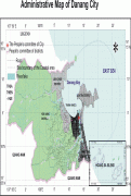
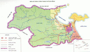
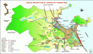
Da Nang (Da Nang)
Da Nang is the commercial and educational centre of Central Vietnam and is the largest city in the region. It has a well-sheltered, easily accessible port, and its location on National Route 1 and the North–South Railway makes it a transport hub. It is within 100 km of several UNESCO World Heritage Sites, including the Imperial City of Huế, the Old Town of Hội An, and the Mỹ Sơn ruins. The city was known as Cửa Hàn during early Đại Việt settlement, and as Tourane (or Turon) during French colonial rule. Before 1997, the city was part of Quang Nam - Da Nang Province.
On 1 January 1997, Da Nang was separated from Quảng Nam Province to become one of four centrally controlled municipalities in Vietnam. Da Nang is designated as a first class city, and has a higher urbanization ratio than any of Vietnam's other provinces or centrally governed cities.
Da Nang has a Human Development Index of 0.779 (high), ranking fifth among all municipalities and provinces of Vietnam.
Most of the names by which Da Nang has been known make reference to its position at the Hàn River estuary. The city's present name is generally agreed to be a Vietnamese adaptation of the Cham word da nak, which is translated as "opening of a large river".
Other Chamic sources, with similar definitions, have been proposed. Inrasara (aka Phú Trạm), a researcher specializing in Champa, suggests Da Nang is a variation of the Cham word daknan (lit. "the large water"); Sakaya (aka Văn Món), another Champa researcher, claims a connection with the Raglai word danang, meaning "river source".
Another name given to Da Nang was Cửa Hàn (lit. "mouth of the Han [river] "). The name used by the French, Tourane, is said to derive from this name, by way of a rough transliteration. Notably, this name (spelled "Cua han") appears on maps of the area drafted by Alexandre de Rhodes in 1650. The name Kean (cf. Kẻ Hàn, roughly "Han market") was another name purportedly used during the 17th century to refer to the land at the foot of the Hải Vân Pass.
Other names referring to Da Nang include:
* Vũng Thùng, a colloquial name which survives in folklore.
* Trà Úc, Trà Áo, Trà Sơn and Đồng Long Loan, literary names used by Confucian scholars.
Map - Da Nang (Da Nang)
Map


Country - Vietnam
 |
 |
| Flag of Vietnam | |
Vietnam was inhabited by the Paleolithic age, with states established in the first millennium BC on the Red River Delta in modern-day northern Vietnam. The Han dynasty annexed Northern and Central Vietnam under Chinese rule from 111 BC, until the first dynasty emerged in 939. Successive monarchical dynasties absorbed Chinese influences through Confucianism and Buddhism, and expanded southward to the Mekong Delta, conquering Champa. The Nguyễn—the last imperial dynasty—surrendered to France in 1883. Following the August Revolution, the nationalist Viet Minh under the leadership of communist revolutionary Ho Chi Minh proclaimed independence from France in 1945.
Currency / Language
| ISO | Currency | Symbol | Significant figures |
|---|---|---|---|
| VND | Vietnamese đồng | ₫ | 0 |
| ISO | Language |
|---|---|
| KM | Central Khmer language |
| ZH | Chinese language |
| EN | English language |
| FR | French language |
| VI | Vietnamese language |